Can anyone help with this query?
Dear Archivist,
I’ve lived in Redditch all my life and have walked Musket’s Path and many times and dug spent rounds out of the Butts of the old rifle range.
Walking along Musket’s path most with untrained eyes would not notice that there’s an ancient hedge on top of a bank and ditch. The hedge just looks like the edge of Pitcheroak Wood but I believe that the bank and ditch was topped with a hedge which was subsequently laid in leu of the rifle range being built. This was to prevent the public wandering too close to the butts for obvious reasons!
You probably already know the archaeology of the range but this is what I have found: Early to late Minié bullets. The rifle was in use by the British Army from 1851 to 1855 which gives me an approximate date of when it could have been opened at the earliest. I’ve also found Martini Henry rounds dating from, at the earliest, 1871. Later Lee Enfield .303 Mk VI rounds circa 1903. I know the range was used during both wars and for training Home Guard. (I have found Mill’s bomb parts).
The earliest map I can find online showing the range is 1898.The range is not on the 1813 map.
I would really like to know when the range was built and became operational. Would you be able to help with some dates?
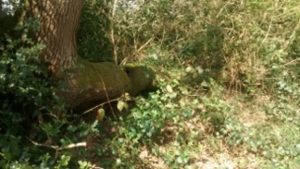
Attached is a photo of the remnants of the laid hedge with, what I believe, a horizontal laid branch or “pleacher” still in existence. For it to be this size the hedge must have been laid many years ago.
Pip Taylor
IM Howard
9 Sep 2020I also have an interest in the rifle range as part of an interest in Pitcheroak Woods in general.
The west side of muskets path there is the remains of a strong hedgerow the was probably intended to keep cattle and to some extent deer out. You can see similar remains along both sides of Red Lane. Now Bromsgrove Road. Technically Pitcheroak is a Coppice, not a wood. All the oak trees are roughly the same age approx 150 years old +/- 10 years. I am not sure if any serious coppicing took place before the woods were sold to the council.
IM Howard
6 Mar 2024I do not think Muskets Path has much to do with the rifle range. I’m sure that the Muscett is derived from an old French word for Sparrowhawk. The open nature of ‘coppice with standards’ woodland to the west of the path and what was described as open scrub land / common land to the east (golf course history page) would have been an ideal habitat for the birds to breed and hunt in.